Safer Sailing with AI

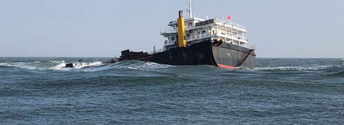
In the last week, the world watched as responders tried to free a cargo ship that had gone aground in the Suez Canal. This incident blocked traffic through a waterway that is critical for commerce. While the location was an unusual one, ship collisions, allisions , and groundings are not uncommon. With all the technology that mariners have access to, combined with how big the ocean is, it should be easy not to have an accident, right?
In the last few years alone, we can see that is not the case. Last year, two cruise ships collided in the Gulf of Mexico. A few years ago, the US Navy had two major collisions over the course of a few months. Each incident was a perfect storm of factors that led to an accident. If you look at the EMSA Marine Casualty report from 2011-2019 there were 25,214 ships involved in accidents. Cost-wise, marine incidents cost approximately $197 million in losses in a year (2017.)
While the exact cause of the grounding in the Suez Canal is still under investigation, we have to ask what can be done to keep these sorts of things from happening in the future. If they do happen again, how can we help mitigate the impact?
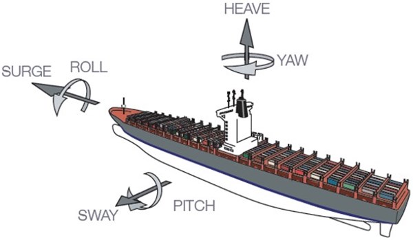
Many factors go into maneuvering a vessel, which gets even more complex when talking about a deep draft vessel going through a restricted channel. A mariner has to monitor the wind, other vessel traffic, the depth of the water, the current, the cargo’s position, and then all the movement of the ship itself (pictured) when maneuvering in a channel.

No matter what technology can provide, you must have a skilled mariner at the helm. Still, a skilled mariner with the best AI tools available would mitigate many situations before they become accidents.
Lt. Gen. Osama Rabie, chairman of the Suez Canal Authority, said in a Monday news conference that “no ship thought to take another route, even though the crisis lasted six days, because the alternative route was more than 10,000 miles. The Suez Canal is still the safest, shortest, and best service course.”
While in this case, it was clear cut that going around the issue would not save time or money, there are instances where a redirect might be feasible, even preferable—setting up a model that identifies the optimal route, including offloading and transiting by land depending on the cargo. Route optimization ahead of time would give companies viable routes to take when similar situations happen again.
The right AI app would automatically re-evaluate the risk-return trade-off based on latest data and recommend optimal rerouting options when available. It would set lines out that told you at which point in your journey towards the canal was it cost-efficient to reroute versus when it was more efficient to continue on the planned route even if the channel is blocked for a certain number of days. By building a model that shows the risk vs. reward, your company would be able to make rapid decisions based on real-time data.
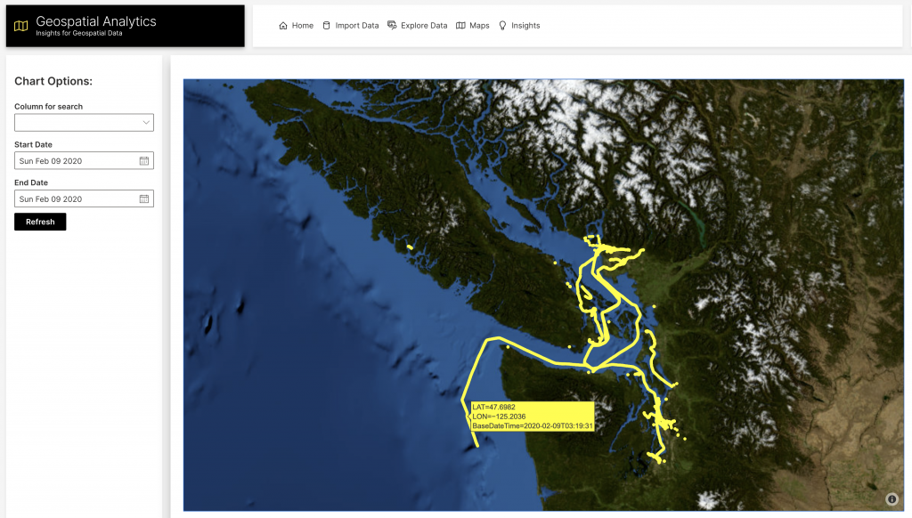

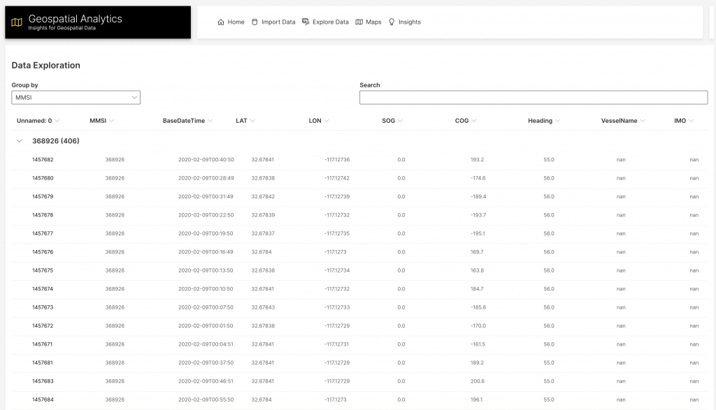

The image above shows the Maritime Mobile Service Identity of each vessel, with their Latitude, Longitude, Speed over Ground (SOG), Course over Ground (COG), and heading. This information is regularly updated as a vessel moves and results in a trackable path.
Route Prediction
The future positions of ships can be predicted based on physical models as well as standard shipping routes. While course trajectory predictions wouldn’t have likely been useful for the Ever Given, because it’s difficult to predict a rare event, they could be used in projecting the expected density of ships in various locations in the future.
Trajectory predictions could also be used to predict whether a ship is behaving unusually. Machine learning software could flag ships that are off their predicted course by a certain distance as potentially suspicious. Then someone could look into whether the ship’s trajectory is truly unusual enough to be concerning.
Or, if we were interested in what types of behavior might be indicative that a ship plans to go off course, we could create a predictive model indicating whether a ship that was currently on course was likely to go off course in the future. The below plot shows the feature importance for an H2O AutoML model predicting the likelihood that a ship would go off course in the future.

The X and Y features are location features, indicating that ships in certain locations are more likely to change course. Distance_23 is the distance traveled between two of the more recent records, SOG_4 and speed_12 are recent speeds, and Length and dim_1 are ship dimensions. So, the model indicates that certain size ships in certain areas are more likely to change course. We can explore the relationship between the features and course changes using partial dependence plots.
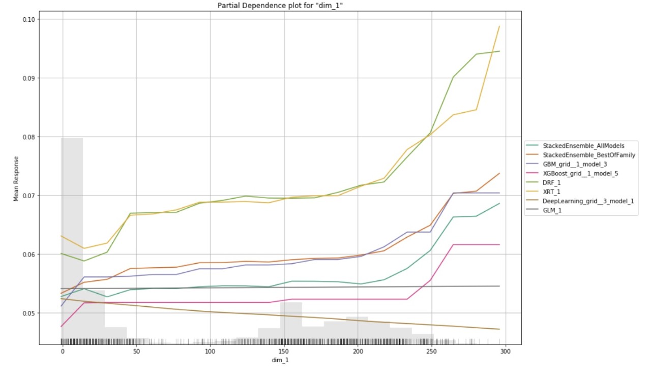

The above partial dependence plots indicate that it was the larger ships, which had traveled a larger distance recently that were more likely to change course.
Of course, it could be that some of the ships flagged as behaving strangely are not actually a concern. But after a human check of the flagged results, the labels could be refined and the model could be retrained to be more accurate at only flagging results that are truly a concern.
Minimize Economic Impact
AI can help identify the logistics chains that will be interrupted by the ships in that region being backed up; as of writing this post, the backup for the Suez Canal, for example, is 422 ships. It is essential to be able to track what was on those ships and what disruptions there will be in the supply chain. Even under normal circumstances, machine learning can be used to predict what wait times would be based on day of the year, time of day, and weather information. It also could be used to predict the time it will take to pass through the canal.
“Aside from the delays directly caused by the closure, there is the inevitable bunching of vessels that occurs as they call at their next ports and as we work through these clashes, we will feel the ripple effects of this closure for some weeks to come,” Ahmed Bashir, Maersk’s head of Global Execution Centres, said in a video posted by the company on YouTube.
Response efforts
A lot was said about digging out the Ever Ready in the Suez Canal but, as with most nautical situations, it isn’t as easy as it looks on the surface. In the Suez case, a “Worm Moon” meant that high tide was 18 inches higher than normal. This means that responders would have 18 more inches under the vessel than usual to float on, so they needed to include that in their calculations. They also needed to take into account the wind; it would make no sense to free the vessel only to have it pushed up aground immediately after, so the wind and current are critical for knowing where to put the tug boats.
The data for all the decisions that need to be made when looking to refloat a vessel could be put into H2O Wave, our open-source Python development framework, to create a model that would tell you the best way to get the job done as well as an idea of how long it would take. Knowing how long it would take would help vessels that are in the back up make decisions on their actions and would help calculate the financial impact of the delays.
Environmental Impact
Often when a ship collides with something or runs aground, there is a high risk of environmental impact. The fuel and other chemicals within a vessel can be exposed through a hull’s breach, leading to an oil or chemical spill. This is something that needs to be considered when looking at moving a ship that might have hull damage from the grounding so that the right assets are in place to keep one incident from becoming an even bigger disaster.
When a spill happens due to a collision, there are a variety of ways that you can stop more fluid from spilling from the vessel, which are all a part of the ship’s damage control program. If something does leak from the ship, or if the response is to a spill from another source (like an oil well), there are a number of ways AI can help responders.
AI, particularly in the field of hydroinformatics , can assist the clean-up of a spill by combining the right data- type of fluid in the water (looking for viscosity,) the water’s temperature, the current in the area, and the wind. Using a combination of physics-based numerical simulations and machine learning methods, you can get a predictive model of where the spill will travel, and you can also predict how much of the liquid will sink or evaporate in a timely manner.
—-
So as you can see there are many ways AI could help mariners avoid accidents, aid in the efficiency of the response to an incident, and keep the global supply chain operating effectively. With H2O the tools to build those applications are available to help the nautical community and responders today. Check out H2O Wave or reach out to us to dive in.


